Where can I find a qualified professional land surveyor?
 All land surveys in New York must be performed by a Professional Land Surveyor who has been licensed and registered to practice in the state.
Surveyors who are members of Nassau-Suffolk Civil Engineers, Inc. are all licensed and registered to practice in New York State. In addition, they have subscribed to the "Code of Practice for Land Surveys" adopted by the New York State Association of Professional Land Surveyors, Inc. This code is designed to help maintain a high standard of care and precision in the preparation of land surveys.
You should inquire whether the surveyor you are considering will certify that his survey has been prepared in accordance with this code and whether he is a member of Nassau-Suffolk Civil Engineers, Inc.
You can find members listed in the classified section of your telephone directory under "Surveyors, Land".
What will a professional land surveyor do to answer these questions?
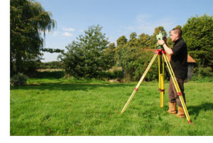
The surveyor will study the documents that you supply, including those in your title search. Then a field survey will be conducted, searching for and obtaining evidence of property boundaries and locating any visible improvements on or near the property. When the field survey is complete, the measurements are mathematically proven and the documents compared with the evidence found. After the exact locations are determined by the surveyor, a report is prepared, usually in the form of a survey map.
What will the survey map show me?
The survey map will show you the location of the property lines as described in the deed and title search. It will show you the dimensions of the land and the location of other lines that affect the property as described in your documents such as easements and rights of way. It will note any variations from the described angles, lengths and areas that the surveyor may find. The map will also depict the location of visible improvements on or near the property and the relation of those improvements to the property's boundary.
It may show that the garden you admired actually belongs to a neighbor or that a part of the land is being used by others. It may show you that the easement, reserved for others in the deed, is just the place where you thought your pool might go someday. It is also possible that there will be evidence of an easement that was not recorded.
With the survey map, your attorney can determine whether Or not property conforms to the local zoning requirements. A survey will aid him in evaluating the effect of any covenants and/or restrictions on the property.
The inside fold of this pamphlet lists many of the questions answered by a survey map.
What if the seller has a previous survey?
First, it will certainly aid your Surveyor in his background research.
Second, a previous survey may not accurately depict current conditions.
Third, a survey done for a previous owner was done for a specific purpose and is not transferable to subsequent purchasers.
What will it cost?
The cost of surveys differs because of varying sizes and locations of properties. Such things as the complexity of the descriptions, terrain and the shape of the property are factors which must be considered. As a result, only a Professional Land Surveyor can accurately estimate the cost of a survey.
The cost of a survey can range from a few hundred to several thousands of dollars. However, most Professional Land Surveyors are willing to discuss their fees and offer an estimate before you authorize a survey. You should keep in mind that the cost of a survey represents a very small percentage of your total investment, but it can help you avoid costly and painful problems in the future.
Protect your interest.
The Professional Land Surveyor locates the property upon which improvements are planned and constructed. His professional services will cost less in time, worry and expense than the cost of moving a building, relocating improvements or defending a law suit in court due to a land boundary controversy. Retain a licensed Professional Land Surveyor prior to the investment of funds as a protection of your interests.